


Ponet-et-St-Auban - Montagne de Desse - Marignac

Philindy26
User


3h30
Difficulty : Medium

FREE GPS app for hiking
 SityTrail
IGN / Geographical institutes
SityTrail Plus
The world is yours!
About
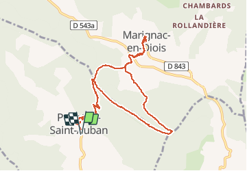
Trail Walking of 11.6 km to be discovered at Auvergne-Rhône-Alpes, Drôme, Ponet-et-Saint-Auban. This trail is proposed by Philindy26.
Description
Randonnée entre deux villages : Ponet-et-St-Auban et Marignac-en-Diois...
Départ du village de Ponet et Saint-Auban (453 m)...
Géolocalisation (Google Maps) : https://goo.gl/maps/ztN7PwWYsGqeroqi8 .
Montée au col de Ponet et Marignac (770 m).
Suivre les crêtes de la Montagne de Desse jusqu'au Pas de Guérin (890 m), descente sur le village de Marignac par Desse (594 m).
Visite du village de Marignac (625 m).
Retour au col de Ponet et Marignac (770 m) par Desse (594 m).
Enfin descente à Ponet par le sentier de montée.
Photos


Positioning
Comments