


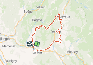
VTT(74) - Tour N°9 - Le Tour de Plaine-Joux par Onnion

HG74250
User

Length
32 km

Max alt
1323 m

Uphill gradient
1173 m
Km-Effort
48 km

Min alt
582 m

Downhill gradient
1183 m
Boucle
Yes
Creation date :
2019-08-03 16:22:25.536
Updated on :
2020-09-20 14:26:42.86
2h48
Difficulty : Difficult

FREE GPS app for hiking
 SityTrail
IGN / Geographical institutes
SityTrail Plus
The world is yours!
About
Trail Mountain bike of 32 km to be discovered at Auvergne-Rhône-Alpes, Upper Savoy, La Tour. This trail is proposed by HG74250.
Positioning
Country:
France
Region :
Auvergne-Rhône-Alpes
Department/Province :
Upper Savoy
Municipality :
La Tour
Location:
Unknown
Start:(Dec)
Start:(UTM)
300729 ; 5112647 (32T) N.
Comments