


Montagnette Combau

nordan
User
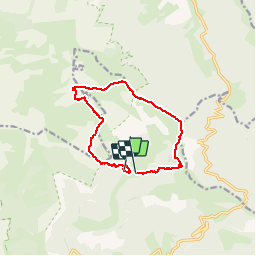

Length
11.7 km

Max alt
1959 m

Uphill gradient
726 m
Km-Effort
22 km

Min alt
1376 m

Downhill gradient
775 m
Boucle
No
Creation date :
2019-07-31 07:54:00.303
Updated on :
2019-08-03 18:50:05.951
6h53
Difficulty : Very easy

FREE GPS app for hiking
 SityTrail
IGN / Geographical institutes
SityTrail Plus
The world is yours!
About
Trail Walking of 11.7 km to be discovered at Auvergne-Rhône-Alpes, Drôme, Châtillon-en-Diois. This trail is proposed by nordan.
Positioning
Country:
France
Region :
Auvergne-Rhône-Alpes
Department/Province :
Drôme
Municipality :
Châtillon-en-Diois
Location:
Treschenu-Creyers
Start:(Dec)
Start:(UTM)
702775 ; 4960186 (31T) N.
Comments