


Circuit des chalets et granges de furfande.03 08 19

Dervalmarc
User
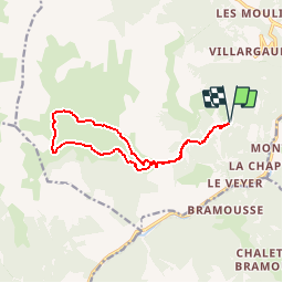

Length
12.8 km

Max alt
2293 m

Uphill gradient
673 m
Km-Effort
22 km

Min alt
1884 m

Downhill gradient
673 m
Boucle
Yes
Creation date :
2019-08-04 10:54:05.839
Updated on :
2019-08-04 10:59:02.973
4h25
Difficulty : Medium

FREE GPS app for hiking
 SityTrail
IGN / Geographical institutes
SityTrail Plus
The world is yours!
About
Trail Walking of 12.8 km to be discovered at Provence-Alpes-Côte d'Azur, Hautes-Alpes, Arvieux. This trail is proposed by Dervalmarc.
Description
longue randonnée dans un cadre proche du Tyrol ou de la Suisse.
Positioning
Country:
France
Region :
Provence-Alpes-Côte d'Azur
Department/Province :
Hautes-Alpes
Municipality :
Arvieux
Location:
Unknown
Start:(Dec)
Start:(UTM)
321774 ; 4955328 (32T) N.
Comments