


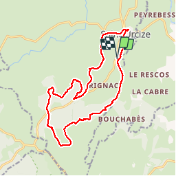
Tour sud de st urcize

mthomas30
User

Length
17.8 km

Max alt
1395 m

Uphill gradient
419 m
Km-Effort
23 km

Min alt
1090 m

Downhill gradient
421 m
Boucle
Yes
Creation date :
2019-08-04 10:06:07.874
Updated on :
2019-08-04 17:45:16.425
5h46
Difficulty : Easy

FREE GPS app for hiking
 SityTrail
IGN / Geographical institutes
SityTrail Plus
The world is yours!
About
Trail Walking of 17.8 km to be discovered at Auvergne-Rhône-Alpes, Cantal, Saint-Urcize. This trail is proposed by mthomas30.
Positioning
Country:
France
Region :
Auvergne-Rhône-Alpes
Department/Province :
Cantal
Municipality :
Saint-Urcize
Location:
Unknown
Start:(Dec)
Start:(UTM)
499890 ; 4948224 (31T) N.
Comments