


LES 2 ALPES - LA MOLIERE - 1

jpb83
User
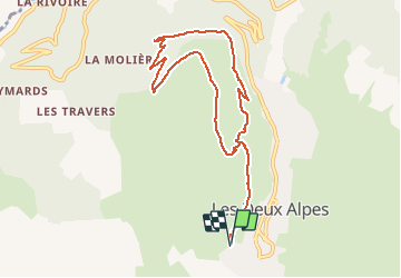

Length
9.5 km

Max alt
1824 m

Uphill gradient
341 m
Km-Effort
14.1 km

Min alt
1571 m

Downhill gradient
342 m
Boucle
Yes
Creation date :
2019-08-04 19:34:33.015
Updated on :
2019-08-04 19:35:54.0
1h30
Difficulty : Medium

FREE GPS app for hiking
 SityTrail
IGN / Geographical institutes
SityTrail Plus
The world is yours!
About
Trail Running of 9.5 km to be discovered at Auvergne-Rhône-Alpes, Isère, Les Deux Alpes. This trail is proposed by jpb83.
Positioning
Country:
France
Region :
Auvergne-Rhône-Alpes
Department/Province :
Isère
Municipality :
Les Deux Alpes
Location:
Vénosc
Start:(Dec)
Start:(UTM)
272854 ; 4987666 (32T) N.
Comments