


Tour du pays d'Allevard - ét.1

cron
User
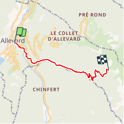

Length
8.7 km

Max alt
1734 m

Uphill gradient
1292 m
Km-Effort
22 km

Min alt
472 m

Downhill gradient
38 m
Boucle
No
Creation date :
2019-08-05 13:55:55.206
Updated on :
2019-08-05 14:03:01.136
9h13
Difficulty : Very difficult

FREE GPS app for hiking
 SityTrail
IGN / Geographical institutes
SityTrail Plus
The world is yours!
About
Trail Walking of 8.7 km to be discovered at Auvergne-Rhône-Alpes, Isère, Allevard. This trail is proposed by cron.
Positioning
Country:
France
Region :
Auvergne-Rhône-Alpes
Department/Province :
Isère
Municipality :
Allevard
Location:
Unknown
Start:(Dec)
Start:(UTM)
271134 ; 5030658 (32T) N.
Comments