


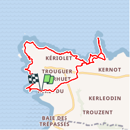
2019 08 0 boucle depuis le vorlen et jusqu'à castelmeur

hal2012
User

Length
8.8 km

Max alt
74 m

Uphill gradient
245 m
Km-Effort
12 km

Min alt
0 m

Downhill gradient
242 m
Boucle
Yes
Creation date :
2019-08-05 09:48:04.546
Updated on :
2019-08-05 14:12:17.287
3h48
Difficulty : Very easy

FREE GPS app for hiking
 SityTrail
IGN / Geographical institutes
SityTrail Plus
The world is yours!
About
Trail Walking of 8.8 km to be discovered at Brittany, Finistère, Cléden-Cap-Sizun. This trail is proposed by hal2012.
Positioning
Country:
France
Region :
Brittany
Department/Province :
Finistère
Municipality :
Cléden-Cap-Sizun
Location:
Unknown
Start:(Dec)
Start:(UTM)
372669 ; 5323616 (30U) N.
Comments