


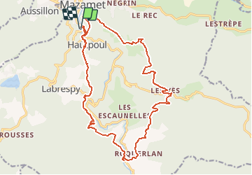
mazamet-hautpoul-roquerlan-mazamet

Dupleix
User

Length
22 km

Max alt
785 m

Uphill gradient
963 m
Km-Effort
35 km

Min alt
278 m

Downhill gradient
959 m
Boucle
Yes
Creation date :
2019-08-05 16:35:05.653
Updated on :
2019-08-05 16:52:38.68
7h09
Difficulty : Very difficult

FREE GPS app for hiking
 SityTrail
IGN / Geographical institutes
SityTrail Plus
The world is yours!
About
Trail Walking of 22 km to be discovered at Occitania, Tarn, Mazamet. This trail is proposed by Dupleix.
Description
boucle de 22km partant du parking de la passerelle sortie de la ville sur la d54. Elle passe a hautpoul en prenant la passerelle,le sentier botanique,canjeulieu,roquerlan,les yès,brettes et mazamet.
Positioning
Country:
France
Region :
Occitania
Department/Province :
Tarn
Municipality :
Mazamet
Location:
Unknown
Start:(Dec)
Start:(UTM)
449534 ; 4814467 (31T) N.
Comments