


Ars 2019 08 06 HS

bstebe
User
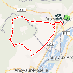

Length
7.7 km

Max alt
359 m

Uphill gradient
216 m
Km-Effort
10.5 km

Min alt
170 m

Downhill gradient
215 m
Boucle
Yes
Creation date :
2019-08-06 06:57:54.972
Updated on :
2019-08-06 09:49:33.858
2h51
Difficulty : Very easy

FREE GPS app for hiking
 SityTrail
IGN / Geographical institutes
SityTrail Plus
The world is yours!
About
Trail Nordic walking of 7.7 km to be discovered at Grand Est, Moselle, Ars-sur-Moselle. This trail is proposed by bstebe.
Positioning
Country:
France
Region :
Grand Est
Department/Province :
Moselle
Municipality :
Ars-sur-Moselle
Location:
Unknown
Start:(Dec)
Start:(UTM)
286584 ; 5439882 (32U) N.
Comments
Le Fort Driant est interdit à toute visite non autorisée par l'armée car c'est un domaine militaire conformément à l'affichage en place...! Outre les risques encourus, vous êtes passible d'une amende. https://m.facebook.com/fortdriant/