


5 luc-la bastide puylaurent

joelinou
User
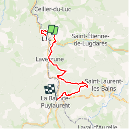

Length
20 km

Max alt
1229 m

Uphill gradient
609 m
Km-Effort
28 km

Min alt
956 m

Downhill gradient
593 m
Boucle
No
Creation date :
2019-08-07 16:55:54.098
Updated on :
2019-08-14 16:44:09.319
--
Difficulty : Difficult

FREE GPS app for hiking
 SityTrail
IGN / Geographical institutes
SityTrail Plus
The world is yours!
About
Trail On foot of 20 km to be discovered at Occitania, Lozère, Luc. This trail is proposed by joelinou.
Description
GR70 CHEMIN DE STEVENSON
Positioning
Country:
France
Region :
Occitania
Department/Province :
Lozère
Municipality :
Luc
Location:
Unknown
Start:(Dec)
Start:(UTM)
570619 ; 4944385 (31T) N.
Comments