


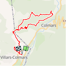
Chalet - Les Espiniers - l'Adroit- Colmars

soca
User

Length
11.1 km

Max alt
1663 m

Uphill gradient
704 m
Km-Effort
20 km

Min alt
1216 m

Downhill gradient
704 m
Boucle
Yes
Creation date :
2019-08-09 04:34:17.389
Updated on :
2019-08-09 04:35:26.716
4h07
Difficulty : Difficult

FREE GPS app for hiking
 SityTrail
IGN / Geographical institutes
SityTrail Plus
The world is yours!
About
Trail Walking of 11.1 km to be discovered at Provence-Alpes-Côte d'Azur, Alpes-de-Haute-Provence, Villars-Colmars. This trail is proposed by soca.
Positioning
Country:
France
Region :
Provence-Alpes-Côte d'Azur
Department/Province :
Alpes-de-Haute-Provence
Municipality :
Villars-Colmars
Location:
Unknown
Start:(Dec)
Start:(UTM)
308875 ; 4893265 (32T) N.
Comments
début diffusé 1h de montée faire puis facile belle vue sur la vallée de colmars les alpes.