


boucle st urcize les sentinelles

mthomas30
User
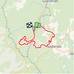

Length
26 km

Max alt
1349 m

Uphill gradient
667 m
Km-Effort
35 km

Min alt
1065 m

Downhill gradient
671 m
Boucle
Yes
Creation date :
2019-08-09 06:59:03.04
Updated on :
2019-08-09 10:26:27.7
2h21
Difficulty : Medium

FREE GPS app for hiking
 SityTrail
IGN / Geographical institutes
SityTrail Plus
The world is yours!
About
Trail Mountain bike of 26 km to be discovered at Auvergne-Rhône-Alpes, Cantal, Saint-Urcize. This trail is proposed by mthomas30.
Positioning
Country:
France
Region :
Auvergne-Rhône-Alpes
Department/Province :
Cantal
Municipality :
Saint-Urcize
Location:
Unknown
Start:(Dec)
Start:(UTM)
499890 ; 4948231 (31T) N.
Comments