


2019 08-10 buron la Tuillère

josy31
User
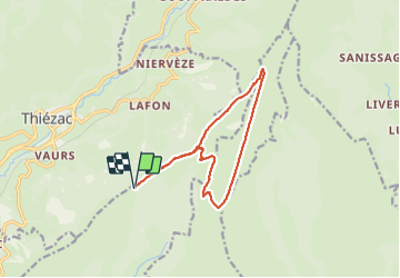

Length
13.2 km

Max alt
1568 m

Uphill gradient
377 m
Km-Effort
18.2 km

Min alt
1311 m

Downhill gradient
377 m
Boucle
Yes
Creation date :
2019-08-10 09:01:27.806
Updated on :
2021-08-01 17:09:33.177
5h01
Difficulty : Easy

FREE GPS app for hiking
 SityTrail
IGN / Geographical institutes
SityTrail Plus
The world is yours!
About
Trail Walking of 13.2 km to be discovered at Auvergne-Rhône-Alpes, Cantal, Saint-Clément. This trail is proposed by josy31.
Description
Très belle randonnée à éviter toutefois en cas de grosse chaleur car aucune ombre sur le trajet
Positioning
Country:
France
Region :
Auvergne-Rhône-Alpes
Department/Province :
Cantal
Municipality :
Saint-Clément
Location:
Unknown
Start:(Dec)
Start:(UTM)
475787 ; 4982807 (31T) N.
Comments