


Villedômer - Le sentier des Bois - 22.4km 265m 5h05 (25mn) - 2019 08 10

Orcal37
User GUIDE
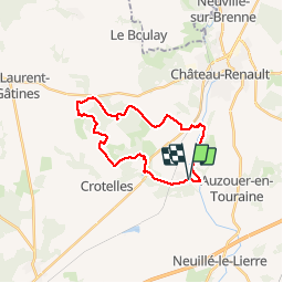

Length
22 km

Max alt
161 m

Uphill gradient
267 m
Km-Effort
26 km

Min alt
76 m

Downhill gradient
266 m
Boucle
Yes
Creation date :
2019-08-10 08:15:36.29
Updated on :
2019-08-11 18:24:46.721
5h05
Difficulty : Easy

FREE GPS app for hiking
 SityTrail
IGN / Geographical institutes
SityTrail Plus
The world is yours!
About
Trail Walking of 22 km to be discovered at Centre-Loire Valley, Indre-et-Loire, Villedômer. This trail is proposed by Orcal37.
Description
Villedômer - Le sentier des Bois - 22.4km 265m 5h05 (25mn) - 2019 08 10
Photos
 - 2019 08 10 - Photo 1")
 - 2019 08 10 - Photo 2")
 - 2019 08 10 - Photo 3")
 - 2019 08 10 - Photo 4")
 - 2019 08 10 - Photo 5")
 - 2019 08 10 - Photo 6")
 - 2019 08 10 - Photo 7")
 - 2019 08 10 - Photo 8")
 - 2019 08 10 - Photo 9")
 - 2019 08 10 - Photo 10")
 - 2019 08 10 - Photo 11")
 - 2019 08 10 - Photo 12")
 - 2019 08 10 - Photo 13")
 - 2019 08 10 - Photo 14")
Positioning
Country:
France
Region :
Centre-Loire Valley
Department/Province :
Indre-et-Loire
Municipality :
Villedômer
Location:
Unknown
Start:(Dec)
Start:(UTM)
341143 ; 5267973 (31T) N.
Comments