


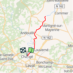
Le long de la Mayenne pendant 20 km et retour

phimar_2612
User

Length
38 km

Max alt
95 m

Uphill gradient
386 m
Km-Effort
43 km

Min alt
47 m

Downhill gradient
384 m
Boucle
Yes
Creation date :
2019-08-10 08:11:48.35
Updated on :
2019-08-10 18:32:55.858
7h06
Difficulty : Easy

FREE GPS app for hiking
 SityTrail
IGN / Geographical institutes
SityTrail Plus
The world is yours!
About
Trail Walking of 38 km to be discovered at Pays de la Loire, Mayenne, Changé. This trail is proposed by phimar_2612.
Positioning
Country:
France
Region :
Pays de la Loire
Department/Province :
Mayenne
Municipality :
Changé
Location:
Unknown
Start:(Dec)
Start:(UTM)
664929 ; 5329819 (30U) N.
Comments