


Grandfresnoy

pascha
User
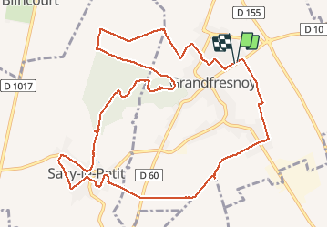

Length
12.6 km

Max alt
134 m

Uphill gradient
157 m
Km-Effort
14.7 km

Min alt
46 m

Downhill gradient
157 m
Boucle
Yes
Creation date :
2019-08-11 07:00:16.0
Updated on :
2019-08-11 10:18:27.492
3h17
Difficulty : Unknown

FREE GPS app for hiking
 SityTrail
IGN / Geographical institutes
SityTrail Plus
The world is yours!
About
Trail Walking of 12.6 km to be discovered at Hauts-de-France, Oise, Grandfresnoy. This trail is proposed by pascha.
Positioning
Country:
France
Region :
Hauts-de-France
Department/Province :
Oise
Municipality :
Grandfresnoy
Location:
Unknown
Start:(Dec)
Start:(UTM)
475147 ; 5469183 (31U) N.
Comments
varié très bien.