


lac de longemer

annamaria
User
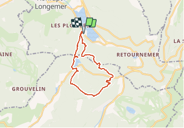

Length
12.2 km

Max alt
1163 m

Uphill gradient
568 m
Km-Effort
19.8 km

Min alt
743 m

Downhill gradient
568 m
Boucle
Yes
Creation date :
2019-08-11 07:40:40.746
Updated on :
2019-08-11 12:50:43.699
5h08
Difficulty : Very easy

FREE GPS app for hiking
 SityTrail
IGN / Geographical institutes
SityTrail Plus
The world is yours!
About
Trail Walking of 12.2 km to be discovered at Grand Est, Vosges, Xonrupt-Longemer. This trail is proposed by annamaria.
Description
difficulte moyenne.tres jolis panoramas superbes chemins
Positioning
Country:
France
Region :
Grand Est
Department/Province :
Vosges
Municipality :
Xonrupt-Longemer
Location:
Unknown
Start:(Dec)
Start:(UTM)
347228 ; 5325761 (32U) N.
Comments