


Ambleny

VANDERPUTTENMi
User GUIDE
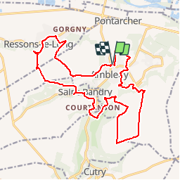

Length
20 km

Max alt
145 m

Uphill gradient
366 m
Km-Effort
25 km

Min alt
43 m

Downhill gradient
368 m
Boucle
Yes
Creation date :
2019-08-11 16:57:04.486
Updated on :
2019-08-11 17:00:34.436
5h23
Difficulty : Very difficult

FREE GPS app for hiking
 SityTrail
IGN / Geographical institutes
SityTrail Plus
The world is yours!
About
Trail Walking of 20 km to be discovered at Hauts-de-France, Aisne, Ambleny. This trail is proposed by VANDERPUTTENMi.
Description
Difficile...
Positioning
Country:
France
Region :
Hauts-de-France
Department/Province :
Aisne
Municipality :
Ambleny
Location:
Unknown
Start:(Dec)
Start:(UTM)
513335 ; 5469792 (31U) N.
Comments