


Säntis 11/08/19

LaurentGILG
User

Length
22 km

Max alt
2452 m

Uphill gradient
2227 m
Km-Effort
52 km

Min alt
870 m

Downhill gradient
2221 m
Boucle
Yes
Creation date :
2019-08-11 06:00:32.24
Updated on :
2019-08-11 18:35:21.595
7h55
Difficulty : Very difficult

FREE GPS app for hiking
 SityTrail
IGN / Geographical institutes
SityTrail Plus
The world is yours!
About
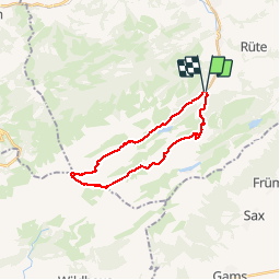
Trail Walking of 22 km to be discovered at Appenzell Innerrhoden, Unknown, Schwende. This trail is proposed by LaurentGILG.
Positioning
Country:
Switzerland
Region :
Appenzell Innerrhoden
Department/Province :
Unknown
Municipality :
Schwende
Location:
Unknown
Start:(Dec)
Start:(UTM)
532290 ; 5236826 (32T) N.
Comments