


Sentier de Pauparelle

frizou83
User
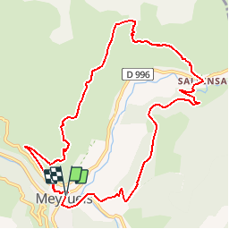

Length
11.5 km

Max alt
1029 m

Uphill gradient
526 m
Km-Effort
18.6 km

Min alt
700 m

Downhill gradient
532 m
Boucle
Yes
Creation date :
2019-08-12 18:40:35.22
Updated on :
2019-08-12 18:41:16.717
3h49
Difficulty : Difficult

FREE GPS app for hiking
 SityTrail
IGN / Geographical institutes
SityTrail Plus
The world is yours!
About
Trail Walking of 11.5 km to be discovered at Occitania, Lozère, Meyrueis. This trail is proposed by frizou83.
Positioning
Country:
France
Region :
Occitania
Department/Province :
Lozère
Municipality :
Meyrueis
Location:
Unknown
Start:(Dec)
Start:(UTM)
534456 ; 4892035 (31T) N.
Comments