


Lorry 2010 08 13 HS

bstebe
User
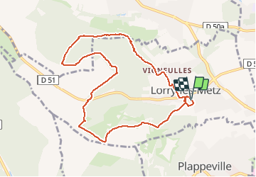

Length
9 km

Max alt
356 m

Uphill gradient
195 m
Km-Effort
11.6 km

Min alt
223 m

Downhill gradient
195 m
Boucle
Yes
Creation date :
2019-08-13 06:58:33.612
Updated on :
2019-08-13 09:43:31.033
2h44
Difficulty : Very easy

FREE GPS app for hiking
 SityTrail
IGN / Geographical institutes
SityTrail Plus
The world is yours!
About
Trail Nordic walking of 9 km to be discovered at Grand Est, Moselle, Lorry-lès-Metz. This trail is proposed by bstebe.
Positioning
Country:
France
Region :
Grand Est
Department/Province :
Moselle
Municipality :
Lorry-lès-Metz
Location:
Unknown
Start:(Dec)
Start:(UTM)
290093 ; 5447185 (32U) N.
Comments