


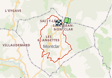
SAINT JEAN MONTCLAR Le tour des chapelles par les chemins d autrefois o

RobinMicheline
User GUIDE

Length
14.5 km

Max alt
1551 m

Uphill gradient
589 m
Km-Effort
22 km

Min alt
1139 m

Downhill gradient
594 m
Boucle
Yes
Creation date :
2019-08-13 04:39:33.34
Updated on :
2020-01-22 19:12:51.056
4h57
Difficulty : Medium

FREE GPS app for hiking
 SityTrail
IGN / Geographical institutes
SityTrail Plus
The world is yours!
About
Trail Walking of 14.5 km to be discovered at Provence-Alpes-Côte d'Azur, Alpes-de-Haute-Provence, Montclar. This trail is proposed by RobinMicheline.
Description
15 kms 4 h 30 marche 600 M dénivelé super bien indiquer
belle vue que des sentiers sympa sur à refaire
Positioning
Country:
France
Region :
Provence-Alpes-Côte d'Azur
Department/Province :
Alpes-de-Haute-Provence
Municipality :
Montclar
Location:
Unknown
Start:(Dec)
Start:(UTM)
289091 ; 4920976 (32T) N.
Comments