


Parilly-Clos Verger 13 08 19

jtraverse
User
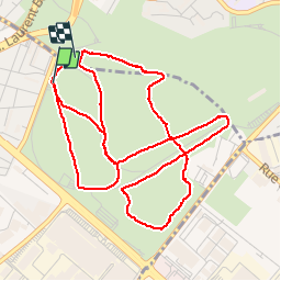

Length
6.8 km

Max alt
200 m

Uphill gradient
67 m
Km-Effort
7.7 km

Min alt
179 m

Downhill gradient
57 m
Boucle
No
Creation date :
2019-08-13 07:20:09.862
Updated on :
2019-08-13 10:24:58.901
3h03
Difficulty : Very easy

FREE GPS app for hiking
 SityTrail
IGN / Geographical institutes
SityTrail Plus
The world is yours!
About
Trail Walking of 6.8 km to be discovered at Auvergne-Rhône-Alpes, Métropole de Lyon, Vénissieux. This trail is proposed by jtraverse.
Positioning
Country:
France
Region :
Auvergne-Rhône-Alpes
Department/Province :
Métropole de Lyon
Municipality :
Vénissieux
Location:
Unknown
Start:(Dec)
Start:(UTM)
647431 ; 5064836 (31T) N.
Comments