


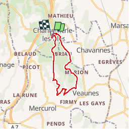
Chantemerle les bles

meillon
User

Length
11.2 km

Max alt
283 m

Uphill gradient
213 m
Km-Effort
14.1 km

Min alt
194 m

Downhill gradient
230 m
Boucle
Yes
Creation date :
2019-08-13 09:44:11.421
Updated on :
2019-08-13 13:51:49.6
4h04
Difficulty : Very easy

FREE GPS app for hiking
 SityTrail
IGN / Geographical institutes
SityTrail Plus
The world is yours!
About
Trail Walking of 11.2 km to be discovered at Auvergne-Rhône-Alpes, Drôme, Chantemerle-les-Blés. This trail is proposed by meillon.
Description
Par monts et par vaux...tranquille
Photos

Positioning
Country:
France
Region :
Auvergne-Rhône-Alpes
Department/Province :
Drôme
Municipality :
Chantemerle-les-Blés
Location:
Unknown
Start:(Dec)
Start:(UTM)
649271 ; 4996929 (31T) N.
Comments