


malet pic du midi

mthomas30
User
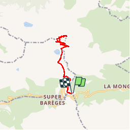

Length
14.2 km

Max alt
2850 m

Uphill gradient
816 m
Km-Effort
25 km

Min alt
2109 m

Downhill gradient
813 m
Boucle
Yes
Creation date :
2019-08-13 09:00:52.205
Updated on :
2019-08-13 18:58:36.832
4h40
Difficulty : Easy

FREE GPS app for hiking
 SityTrail
IGN / Geographical institutes
SityTrail Plus
The world is yours!
About
Trail Walking of 14.2 km to be discovered at Occitania, Hautespyrenees, Bagnères-de-Bigorre. This trail is proposed by mthomas30.
Description
Avec pose déjeuner 45min
Positioning
Country:
France
Region :
Occitania
Department/Province :
Hautespyrenees
Municipality :
Bagnères-de-Bigorre
Location:
Unknown
Start:(Dec)
Start:(UTM)
267020 ; 4754629 (31T) N.
Comments