


SEYNES LES ALPES Saint PONS. Circuit du Chateau o

RobinMicheline
User GUIDE
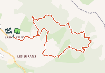

Length
15.5 km

Max alt
1787 m

Uphill gradient
677 m
Km-Effort
25 km

Min alt
1339 m

Downhill gradient
680 m
Boucle
Yes
Creation date :
2019-08-14 04:18:37.779
Updated on :
2020-01-22 19:13:36.922
5h59
Difficulty : Difficult

FREE GPS app for hiking
 SityTrail
IGN / Geographical institutes
SityTrail Plus
The world is yours!
About
Trail Walking of 15.5 km to be discovered at Provence-Alpes-Côte d'Azur, Alpes-de-Haute-Provence, Seyne. This trail is proposed by RobinMicheline.
Description
15 kms 5 h de marche Belle randonnée vu chamois. Pas toujours bien indiquer. sentier après chateau limite
Positioning
Country:
France
Region :
Provence-Alpes-Côte d'Azur
Department/Province :
Alpes-de-Haute-Provence
Municipality :
Seyne
Location:
Unknown
Start:(Dec)
Start:(UTM)
291153 ; 4914087 (32T) N.
Comments