


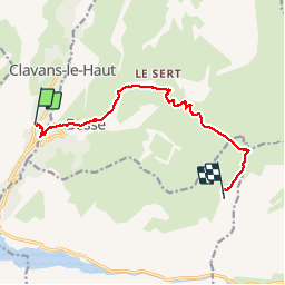
20190814 Clavant le bas Mouterres

Childebert
User

Length
10.4 km

Max alt
2258 m

Uphill gradient
1087 m
Km-Effort
22 km

Min alt
1276 m

Downhill gradient
211 m
Boucle
No
Creation date :
2019-08-14 06:21:31.011
Updated on :
2019-08-21 14:31:09.783
6h48
Difficulty : Difficult

FREE GPS app for hiking
 SityTrail
IGN / Geographical institutes
SityTrail Plus
The world is yours!
About
Trail Walking of 10.4 km to be discovered at Auvergne-Rhône-Alpes, Isère, Clavans-en-Haut-Oisans. This trail is proposed by Childebert.
Positioning
Country:
France
Region :
Auvergne-Rhône-Alpes
Department/Province :
Isère
Municipality :
Clavans-en-Haut-Oisans
Location:
Unknown
Start:(Dec)
Start:(UTM)
276000 ; 4994831 (32T) N.
Comments