


route des vins

Bernardb44
User
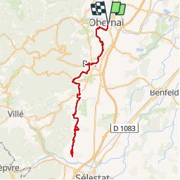

Length
61 km

Max alt
277 m

Uphill gradient
702 m
Km-Effort
70 km

Min alt
174 m

Downhill gradient
707 m
Boucle
Yes
Creation date :
2019-08-14 08:48:47.774
Updated on :
2019-08-14 14:27:24.825
5h37
Difficulty : Very easy

FREE GPS app for hiking
 SityTrail
IGN / Geographical institutes
SityTrail Plus
The world is yours!
About
Trail Road bike of 61 km to be discovered at Grand Est, Bas-Rhin, Obernai. This trail is proposed by Bernardb44.
Positioning
Country:
France
Region :
Grand Est
Department/Province :
Bas-Rhin
Municipality :
Obernai
Location:
Unknown
Start:(Dec)
Start:(UTM)
388108 ; 5368520 (32U) N.
Comments