


Le Senepy depart Cleau retour Cleau

claude nier
User
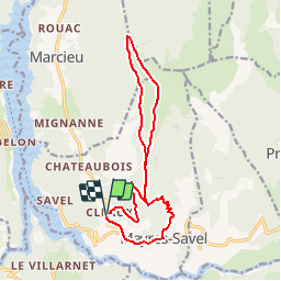

Length
15.3 km

Max alt
1766 m

Uphill gradient
1155 m
Km-Effort
31 km

Min alt
646 m

Downhill gradient
1167 m
Boucle
Yes
Creation date :
2019-08-14 16:57:56.807
Updated on :
2019-08-14 17:00:28.812
6h06
Difficulty : Very difficult

FREE GPS app for hiking
 SityTrail
IGN / Geographical institutes
SityTrail Plus
The world is yours!
About
Trail Walking of 15.3 km to be discovered at Auvergne-Rhône-Alpes, Isère, Mayres-Savel. This trail is proposed by claude nier.
Description
Tres belle rando pour de beaux paysages ...
Positioning
Country:
France
Region :
Auvergne-Rhône-Alpes
Department/Province :
Isère
Municipality :
Mayres-Savel
Location:
Unknown
Start:(Dec)
Start:(UTM)
713634 ; 4973141 (31T) N.
Comments