


2013-09-01 Picnic CVA Couscous au nid des oiseaux

holtzv
User GUIDE
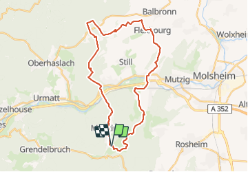

Length
32 km

Max alt
359 m

Uphill gradient
662 m
Km-Effort
41 km

Min alt
195 m

Downhill gradient
664 m
Boucle
Yes
Creation date :
2014-12-10 00:00:00.0
Updated on :
2014-12-10 00:00:00.0
4h59
Difficulty : Medium

FREE GPS app for hiking
 SityTrail
IGN / Geographical institutes
SityTrail Plus
The world is yours!
About
Trail Equestrian of 32 km to be discovered at Grand Est, Bas-Rhin, Rosheim. This trail is proposed by holtzv.

Positioning
Country:
France
Region :
Grand Est
Department/Province :
Bas-Rhin
Municipality :
Rosheim
Location:
Unknown
Start:(Dec)
Start:(UTM)
381078 ; 5372605 (32U) N.
Comments