


Contamines chalets miages Truc

c.gourme
User
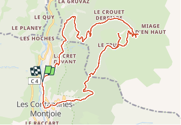

Length
13.8 km

Max alt
1797 m

Uphill gradient
783 m
Km-Effort
24 km

Min alt
1114 m

Downhill gradient
780 m
Boucle
Yes
Creation date :
2019-08-15 09:08:16.0
Updated on :
2020-09-13 12:07:54.281
4h34
Difficulty : Easy

FREE GPS app for hiking
 SityTrail
IGN / Geographical institutes
SityTrail Plus
The world is yours!
About
Trail Walking of 13.8 km to be discovered at Auvergne-Rhône-Alpes, Upper Savoy, Les Contamines-Montjoie. This trail is proposed by c.gourme.
Positioning
Country:
France
Region :
Auvergne-Rhône-Alpes
Department/Province :
Upper Savoy
Municipality :
Les Contamines-Montjoie
Location:
Unknown
Start:(Dec)
Start:(UTM)
323427 ; 5077402 (32T) N.
Comments