


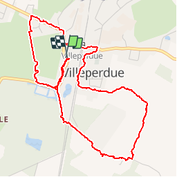
Villeperdue - 5.6km 25m 1h00 - 2019 08 16

Orcal37
User GUIDE

Length
5.6 km

Max alt
122 m

Uphill gradient
27 m
Km-Effort
6 km

Min alt
104 m

Downhill gradient
26 m
Boucle
Yes
Creation date :
2019-08-16 12:38:16.657
Updated on :
2019-08-17 11:06:03.457
1h00
Difficulty : Very easy

FREE GPS app for hiking
 SityTrail
IGN / Geographical institutes
SityTrail Plus
The world is yours!
About
Trail Walking of 5.6 km to be discovered at Centre-Loire Valley, Indre-et-Loire, Villeperdue. This trail is proposed by Orcal37.
Description
Villeperdue - 5.6km 25m 1h00 - 2019 08 16
Photos


Positioning
Country:
France
Region :
Centre-Loire Valley
Department/Province :
Indre-et-Loire
Municipality :
Villeperdue
Location:
Unknown
Start:(Dec)
Start:(UTM)
320620 ; 5230206 (31T) N.
Comments