


VERNET parking du bélier. col de Mariaud cabane Val pousane o

RobinMicheline
User GUIDE
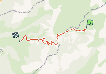

Length
5.8 km

Max alt
1842 m

Uphill gradient
29 m
Km-Effort
8 km

Min alt
1274 m

Downhill gradient
579 m
Boucle
No
Creation date :
2019-08-17 12:29:16.595
Updated on :
2020-01-22 19:43:50.414
1h41
Difficulty : Medium

FREE GPS app for hiking
 SityTrail
IGN / Geographical institutes
SityTrail Plus
The world is yours!
About
Trail Walking of 5.8 km to be discovered at Provence-Alpes-Côte d'Azur, Alpes-de-Haute-Provence, Prads-Haute-Bléone. This trail is proposed by RobinMicheline.
Description
640 m dénivelé 2 h 6 kms
Positioning
Country:
France
Region :
Provence-Alpes-Côte d'Azur
Department/Province :
Alpes-de-Haute-Provence
Municipality :
Prads-Haute-Bléone
Location:
Prads
Start:(Dec)
Start:(UTM)
296220 ; 4906597 (32T) N.
Comments