


marae

orsel
User GUIDE
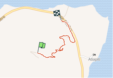

Length
869 m

Max alt
113 m

Uphill gradient
2 m
Km-Effort
1.2 km

Min alt
6 m

Downhill gradient
96 m
Boucle
No
Creation date :
2019-08-18 03:09:11.066
Updated on :
2019-08-18 06:53:28.809
20m
Difficulty : Very easy

FREE GPS app for hiking
 SityTrail
IGN / Geographical institutes
SityTrail Plus
The world is yours!
About
Trail Walking of 869 m to be discovered at Unknown, Leeward Islands, Taputapuatea. This trail is proposed by orsel.
Positioning
Country:
France
Region :
Unknown
Department/Province :
Leeward Islands
Municipality :
Taputapuatea
Location:
Opoa
Start:(Dec)
Start:(UTM)
674508 ; 8137612 (5K) S.
Comments