


Chantemelle 15 km adeps 2019

Dom62
User
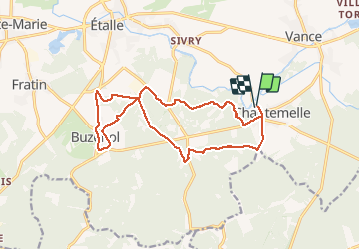

Length
15.5 km

Max alt
369 m

Uphill gradient
177 m
Km-Effort
17.8 km

Min alt
333 m

Downhill gradient
177 m
Boucle
Yes
Creation date :
2019-08-18 08:18:34.19
Updated on :
2019-08-18 12:15:12.551
3h02
Difficulty : Easy

FREE GPS app for hiking
 SityTrail
IGN / Geographical institutes
SityTrail Plus
The world is yours!
About
Trail Walking of 15.5 km to be discovered at Wallonia, Luxembourg, Étalle. This trail is proposed by Dom62.
Positioning
Country:
Belgium
Region :
Wallonia
Department/Province :
Luxembourg
Municipality :
Étalle
Location:
Chantemelle
Start:(Dec)
Start:(UTM)
691224 ; 5503637 (31U) N.
Comments