


F26 Bénevise la Tête Chevalière

ageo
User
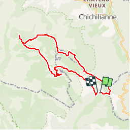

Length
17.9 km

Max alt
1959 m

Uphill gradient
853 m
Km-Effort
29 km

Min alt
1459 m

Downhill gradient
873 m
Boucle
Yes
Creation date :
2017-06-05 00:00:00.0
Updated on :
2017-06-05 00:00:00.0
7h00
Difficulty : Medium

FREE GPS app for hiking
 SityTrail
IGN / Geographical institutes
SityTrail Plus
The world is yours!
About
Trail Walking of 17.9 km to be discovered at Auvergne-Rhône-Alpes, Drôme, Châtillon-en-Diois. This trail is proposed by ageo.
Description
LCV. Beaucoup de hors sentiers.
Positioning
Country:
France
Region :
Auvergne-Rhône-Alpes
Department/Province :
Drôme
Municipality :
Châtillon-en-Diois
Location:
Treschenu-Creyers
Start:(Dec)
Start:(UTM)
703736 ; 4961146 (31T) N.
Comments