


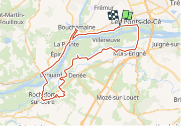
Bord de Loire et GR

xst
User

Length
39 km

Max alt
71 m

Uphill gradient
337 m
Km-Effort
43 km

Min alt
9 m

Downhill gradient
339 m
Boucle
Yes
Creation date :
2019-08-18 11:58:32.662
Updated on :
2019-08-18 16:21:29.466
3h34
Difficulty : Medium

FREE GPS app for hiking
 SityTrail
IGN / Geographical institutes
SityTrail Plus
The world is yours!
About
Trail Mountain bike of 39 km to be discovered at Pays de la Loire, Maine-et-Loire, Sainte-Gemmes-sur-Loire. This trail is proposed by xst.
Description
départ au camping du Jard à sainte Gemmes.
Positioning
Country:
France
Region :
Pays de la Loire
Department/Province :
Maine-et-Loire
Municipality :
Sainte-Gemmes-sur-Loire
Location:
Unknown
Start:(Dec)
Start:(UTM)
684890 ; 5255168 (30T) N.
Comments