Trail Nordic walking La Grave - Ecrins2 - Col du lautaret - V0 - Photo

Ecrins2 - Col du lautaret - V0

 zemarge
zemarge

User

© OpenStreetMap contributors
Length
Length
14.7 km
Max alt
Max alt
2064 m
Uphill gradient
Uphill gradient
904 m
Km-Effort
Km-Effort  
26 km
Min alt
Min alt
1457 m
Downhill gradient
Downhill gradient
724 m
Boucle
Boucle
No
Creation date :
2014-12-10 00:00:00.0
Updated on :
2014-12-10 00:00:00.0

(0 Reviews)

Nordic walking
Nordic walking
5h35
Difficulty : Medium

Scan this QR Code to open this trail in the SityTrail application

FREE GPS app for hiking

Logo SityTrail SityTrail

IGN / Geographical institutes

Download SityTrail from the App Store Download SityTrail from Google Play

Logo SityTrail SityTrail World

The world is yours!

Download SityTrail from the App Store Download SityTrail from Google Play Download SityTrail on Huawei AppGallery

About

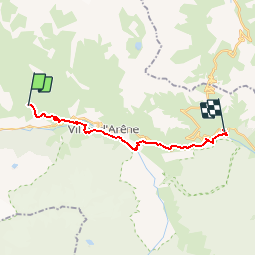
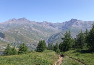
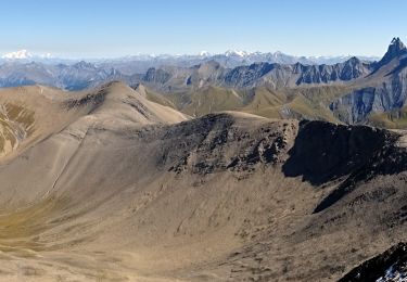
Trail Nordic walking of 14.7 km to be discovered at Provence-Alpes-Côte d'Azur, Hautes-Alpes, La Grave. This trail is proposed by zemarge.

Description

Col du lautaret ==> Refuge de l’Alpe de Villar d’Arene

Elevation profile

Positioning

Country:
France
Region :
Provence-Alpes-Côte d'Azur
Department/Province :
Hautes-Alpes
Municipality :
La Grave
Location:
Unknown
Start:(UTM)
286165 ; 4992547 (32T) N.

Trails nearby

Trail Walking La Grave - L'aiguille du Goléon - Photo
Walking
tracegps

Walking

Very difficult
(1)
La Grave, Provence-Alpes-Côte d'Azur, Hautes-Alpes, France
9.1 km | 25 km-effort
5h 0min
No
Trail Walking La Grave - vallons de la Meije : lac Puy Vachère - Photo
Walking
GUIDE
nadinebondoux

Walking

Very difficult
La Grave, Provence-Alpes-Côte d'Azur, Hautes-Alpes, France
12.7 km | 27 km-effort
5h 44min
Yes
Trail Walking Villar-d'Arêne - SityTrail - Lac du pontet et l'Aiguillon - Photo
Walking

Walking

Medium
(1)
Villar-d'Arêne, Provence-Alpes-Côte d'Azur, Hautes-Alpes, France
5.7 km | 9.6 km-effort
2h 10min
Yes
Trail Walking La Grave - 2020-09-03 Marche Tour de la Grave au plateau d'Emparis par le Pic du Mas de la Grave (3 jours) - Photo
Walking
GUIDE
holtzv

Walking

Medium
La Grave, Provence-Alpes-Côte d'Azur, Hautes-Alpes, France
51 km | 88 km-effort
17h 56min
No
Trail Walking La Grave - 2020-09-03 Marche La Grave au Refuge du Pic du Mas de la Grave - Photo
Walking
GUIDE
holtzv

Walking

Very easy
La Grave, Provence-Alpes-Côte d'Azur, Hautes-Alpes, France
12.2 km | 23 km-effort
4h 58min
No
Trail Walking La Grave - 2020-09-06 Marche La Grave Gare de Peyrou d'Amont au Col des Ruillans - Photo
Walking
GUIDE
holtzv

Walking

Medium
La Grave, Provence-Alpes-Côte d'Azur, Hautes-Alpes, France
6.2 km | 15.7 km-effort
3h 30min
No
Trail Walking La Grave - 2020-09-04 Marche Pic du Mas de la Grave Refuge du Fay - Photo
Walking
GUIDE
holtzv

Walking

Medium
La Grave, Provence-Alpes-Côte d'Azur, Hautes-Alpes, France
17.4 km | 32 km-effort
6h 54min
No
Trail Walking La Grave - Oisans : AR La grave au col de Ruillans (Glacier de Girose) par col du Lac .crea - Photo
Walking
PatDev

Walking

Difficult
(1)
La Grave, Provence-Alpes-Côte d'Azur, Hautes-Alpes, France
16.6 km | 41 km-effort
3h 32min
Yes
Trail Walking La Grave - Côte Rouge  - Photo
Walking
GuyVachet

Walking

Very difficult
La Grave, Provence-Alpes-Côte d'Azur, Hautes-Alpes, France
11.3 km | 23 km-effort
6h 6min
Yes


Close
My subscriptions