


Hautgné - Fontin - Hautgne

Alizée.pee
User GUIDE
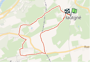

Length
4.7 km

Max alt
230 m

Uphill gradient
68 m
Km-Effort
5.6 km

Min alt
177 m

Downhill gradient
68 m
Boucle
Yes
Creation date :
2019-08-19 08:06:24.0
Updated on :
2019-08-19 08:59:03.834
37m
Difficulty : Unknown

FREE GPS app for hiking
 SityTrail
IGN / Geographical institutes
SityTrail Plus
The world is yours!
About
Trail Running of 4.7 km to be discovered at Wallonia, Liège, Sprimont. This trail is proposed by Alizée.pee.
Description
Belle petite course à pied, beaux paysages et pas trop difficile.
Positioning
Country:
Belgium
Region :
Wallonia
Department/Province :
Liège
Municipality :
Sprimont
Location:
Dolembreux
Start:(Dec)
Start:(UTM)
684780 ; 5601712 (31U) N.
Comments