


Calvisson avec ses moulins 21 08 2019

poisson1103
User
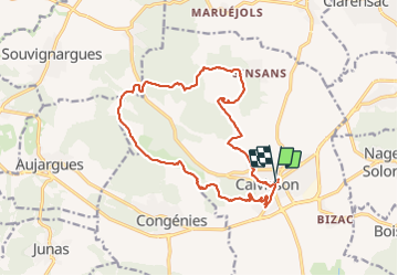

Length
18 km

Max alt
207 m

Uphill gradient
361 m
Km-Effort
23 km

Min alt
55 m

Downhill gradient
363 m
Boucle
Yes
Creation date :
2019-08-21 05:43:43.575
Updated on :
2022-03-08 14:46:28.929
6h32
Difficulty : Very easy

FREE GPS app for hiking
 SityTrail
IGN / Geographical institutes
SityTrail Plus
The world is yours!
About
Trail Walking of 18 km to be discovered at Occitania, Gard, Calvisson. This trail is proposed by poisson1103.
Description
vue sur l'hortus et le vaunage
Photos


Positioning
Country:
France
Region :
Occitania
Department/Province :
Gard
Municipality :
Calvisson
Location:
Unknown
Start:(Dec)
Start:(UTM)
595953 ; 4848757 (31T) N.
Comments