


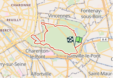
Bois de Vincennes

Surot
User

Length
14.6 km

Max alt
73 m

Uphill gradient
110 m
Km-Effort
16 km

Min alt
42 m

Downhill gradient
113 m
Boucle
Yes
Creation date :
2019-08-21 08:29:52.0
Updated on :
2023-04-16 15:55:13.58
3h38
Difficulty : Difficult

FREE GPS app for hiking
 SityTrail
IGN / Geographical institutes
SityTrail Plus
The world is yours!
About
Trail Walking of 14.6 km to be discovered at Ile-de-France, Paris, Paris. This trail is proposed by Surot.
Description
Boucle de 13-14km dans le bois de Vincennes par chacun des 4 lacs
Positioning
Country:
France
Region :
Ile-de-France
Department/Province :
Paris
Municipality :
Paris
Location:
12th Arrondissement
Start:(Dec)
Start:(UTM)
460107 ; 5408138 (31U) N.
Comments