


Beauvezer - La Valette

soca
User
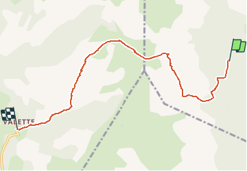

Length
7.1 km

Max alt
1972 m

Uphill gradient
484 m
Km-Effort
14.1 km

Min alt
1303 m

Downhill gradient
662 m
Boucle
No
Creation date :
2019-08-21 13:31:49.851
Updated on :
2019-08-21 13:32:44.644
2h42
Difficulty : Medium

FREE GPS app for hiking
 SityTrail
IGN / Geographical institutes
SityTrail Plus
The world is yours!
About
Trail Walking of 7.1 km to be discovered at Provence-Alpes-Côte d'Azur, Alpes-de-Haute-Provence, Beauvezer. This trail is proposed by soca.
Positioning
Country:
France
Region :
Provence-Alpes-Côte d'Azur
Department/Province :
Alpes-de-Haute-Provence
Municipality :
Beauvezer
Location:
Unknown
Start:(Dec)
Start:(UTM)
305752 ; 4891064 (32T) N.
Comments