Trail Walking Locarn - Landes de Locarn et Gorges du Corong - Photo

Landes de Locarn et Gorges du Corong

 PAM2235
PAM2235

User

© OpenStreetMap contributors
Length
Length
9.8 km
Max alt
Max alt
276 m
Uphill gradient
Uphill gradient
173 m
Km-Effort
Km-Effort  
12.1 km
Min alt
Min alt
148 m
Downhill gradient
Downhill gradient
172 m
Boucle
Boucle
Yes
Creation date :
2019-08-21 12:37:53.466
Updated on :
2019-08-21 17:43:01.044

(0 Reviews)

Walking
Walking
2h45
Difficulty : Medium

Scan this QR Code to open this trail in the SityTrail application

FREE GPS app for hiking

Logo SityTrail SityTrail

IGN / Geographical institutes

Download SityTrail from the App Store Download SityTrail from Google Play

Logo SityTrail SityTrail World

The world is yours!

Download SityTrail from the App Store Download SityTrail from Google Play Download SityTrail on Huawei AppGallery

About

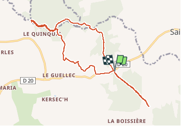
Trail Walking of 9.8 km to be discovered at Brittany, Côtes-d'Armor, Locarn. This trail is proposed by PAM2235.

Description

Locarn  (22) : circuit pédestre à travers les landes de Locarn et les gorges du Corong.

Elevation profile

Positioning

Country:
France
Region :
Brittany
Department/Province :
Côtes-d'Armor
Municipality :
Locarn
Location:
Unknown
Start:(UTM)
472801 ; 5353408 (30U) N.

Trails nearby

Trail Walking Locarn - Circuit landes de Locarn Corong - Photo
Walking
runarlejou

Walking

Medium
Locarn, Brittany, Côtes-d'Armor, France
5.4 km | 6.7 km-effort
2h 3min
Yes
Trail Walking Locarn - Gorges du Corong - Photo
Walking
FabienneD

Walking

Easy
Locarn, Brittany, Côtes-d'Armor, France
5 km | 6.4 km-effort
1h 24min
Yes
Trail Walking Duault - Duault - circuit des collines - Photo
Walking
FabienneD

Walking

Medium
Duault, Brittany, Côtes-d'Armor, France
14 km | 17.6 km-effort
3h 46min
Yes


Close
My subscriptions