


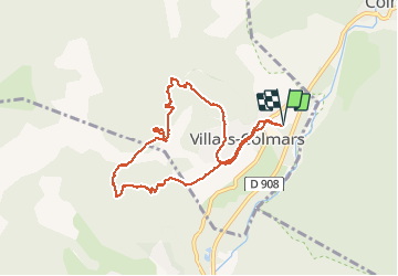
Chalet Villars - Croix du Puy

soca
User

Length
9 km

Max alt
1724 m

Uphill gradient
532 m
Km-Effort
16.1 km

Min alt
1216 m

Downhill gradient
532 m
Boucle
Yes
Creation date :
2019-08-22 05:38:11.56
Updated on :
2019-08-22 12:48:33.817
3h05
Difficulty : Medium

FREE GPS app for hiking
 SityTrail
IGN / Geographical institutes
SityTrail Plus
The world is yours!
About
Trail Walking of 9 km to be discovered at Provence-Alpes-Côte d'Azur, Alpes-de-Haute-Provence, Villars-Colmars. This trail is proposed by soca.
Positioning
Country:
France
Region :
Provence-Alpes-Côte d'Azur
Department/Province :
Alpes-de-Haute-Provence
Municipality :
Villars-Colmars
Location:
Unknown
Start:(Dec)
Start:(UTM)
308863 ; 4893259 (32T) N.
Comments