


Wikiloc - Parc National de la Gaspésie - Mont Ernest Laforce

Alizée.pee
User GUIDE
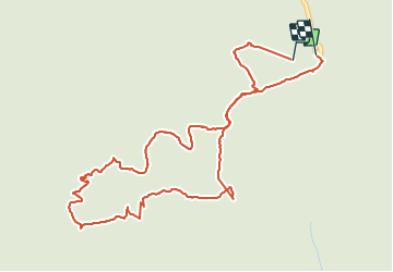

Length
5.5 km

Max alt
830 m

Uphill gradient
227 m
Km-Effort
8.6 km

Min alt
651 m

Downhill gradient
229 m
Boucle
Yes
Creation date :
2019-08-22 12:16:13.715
Updated on :
2019-08-22 12:17:40.246
1h46
Difficulty : Medium

FREE GPS app for hiking
 SityTrail
IGN / Geographical institutes
SityTrail Plus
The world is yours!
About
Trail Walking of 5.5 km to be discovered at Quebec, La Haute-Gaspésie, Mont-Albert. This trail is proposed by Alizée.pee.
Description
Randonnée familiale avec une magnifique vue sur les monts Albert et Jacques-Cartier. Vous aurez peut être la possibilité de voir des Caribous.
Positioning
Country:
Canada
Region :
Quebec
Department/Province :
La Haute-Gaspésie
Municipality :
Mont-Albert
Location:
Unknown
Start:(Dec)
Start:(UTM)
714983 ; 5423268 (19U) N.
Comments