


Wikiloc - La roche et la coulée - parc national du mont tremblant

Alizée.pee
User GUIDE
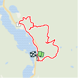

Length
8.4 km

Max alt
603 m

Uphill gradient
354 m
Km-Effort
13.1 km

Min alt
340 m

Downhill gradient
351 m
Boucle
Yes
Creation date :
2019-08-22 12:47:59.536
Updated on :
2019-08-22 12:49:46.557
2h42
Difficulty : Medium

FREE GPS app for hiking
 SityTrail
IGN / Geographical institutes
SityTrail Plus
The world is yours!
About
Trail Walking of 8.4 km to be discovered at Quebec, Les Laurentides, Lac-Supérieur. This trail is proposed by Alizée.pee.
Description
Belle randonnée avec de nombreux points de vue. C'est l'un des plus grands parcs du Québec. A un moment donné, le belvédère laisse place à de magnifiques paysages.
Positioning
Country:
Canada
Region :
Quebec
Department/Province :
Les Laurentides
Municipality :
Lac-Supérieur
Location:
Unknown
Start:(Dec)
Start:(UTM)
538558 ; 5130810 (18T) N.
Comments