


Argy - Le Tour

Yanitch
User
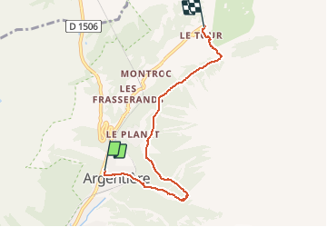

Length
5.3 km

Max alt
1540 m

Uphill gradient
375 m
Km-Effort
9.5 km

Min alt
1256 m

Downhill gradient
151 m
Boucle
No
Creation date :
2019-08-22 11:09:52.96
Updated on :
2019-08-22 12:48:20.387
1h37
Difficulty : Very easy

FREE GPS app for hiking
 SityTrail
IGN / Geographical institutes
SityTrail Plus
The world is yours!
About
Trail Walking of 5.3 km to be discovered at Auvergne-Rhône-Alpes, Upper Savoy, Chamonix-Mont-Blanc. This trail is proposed by Yanitch.
Positioning
Country:
France
Region :
Auvergne-Rhône-Alpes
Department/Province :
Upper Savoy
Municipality :
Chamonix-Mont-Blanc
Location:
Unknown
Start:(Dec)
Start:(UTM)
339503 ; 5094451 (32T) N.
Comments