Trail Walking Beaupré - Wikiloc - Québec Mont Saint Anne Juillet 2004 - Photo

Wikiloc - Québec Mont Saint Anne Juillet 2004

 Alizée.pee
Alizée.pee

User GUIDE

© OpenStreetMap contributors
Length
Length
7.4 km
Max alt
Max alt
800 m
Uphill gradient
Uphill gradient
626 m
Km-Effort
Km-Effort  
15.8 km
Min alt
Min alt
174 m
Downhill gradient
Downhill gradient
621 m
Boucle
Boucle
Yes
Creation date :
2019-08-22 12:58:33.13
Updated on :
2019-08-22 13:01:02.636

(0 Reviews)

Walking
Walking
3h06
Difficulty : Difficult

Scan this QR Code to open this trail in the SityTrail application

FREE GPS app for hiking

Logo SityTrail SityTrail

IGN / Geographical institutes

Download SityTrail from the App Store Download SityTrail from Google Play

Logo SityTrail SityTrail World

The world is yours!

Download SityTrail from the App Store Download SityTrail from Google Play Download SityTrail on Huawei AppGallery

About

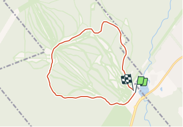
Trail Walking of 7.4 km to be discovered at Quebec, La Côte-de-Beaupré, Beaupré. This trail is proposed by Alizée.pee.

Description

Destination offrant de nombreuses activités de plein air. Il se dresse depuis les berges du Lac Saint-Laurent offrant de points de vue impressionnants de Charlevoix et du Québec. Il y a la possibilité , une fois arrivé au sommet, de redescendre en télécabines. Il faut néanmoins se procurer les billets à la base de la montagne.

Elevation profile

Positioning

Country:
Canada
Region :
Quebec
Department/Province :
La Côte-de-Beaupré
Municipality :
Beaupré
Location:
Unknown
Start:(UTM)
355378 ; 5215468 (19T) N.

Trails nearby

Trail Walking Saint-Ferréol-les-Neiges - Trail Planner Map - Photo
Walking
GUIDE
Alizée.pee

Walking

Difficult
Saint-Ferréol-les-Neiges, Quebec, La Côte-de-Beaupré, Canada
22 km | 34 km-effort
7h 2min
Yes


Close
My subscriptions