


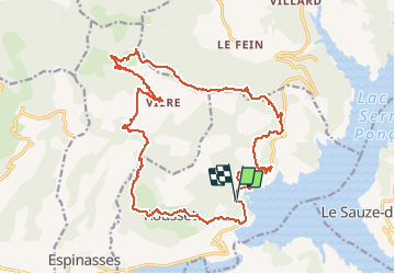
Raid VTT 2019 CMCAS pays de Savoie Jour 4 Rousset

StephaneBM
User

Length
24 km

Max alt
1551 m

Uphill gradient
1096 m
Km-Effort
38 km

Min alt
800 m

Downhill gradient
1100 m
Boucle
Yes
Creation date :
2019-08-22 07:37:23.099
Updated on :
2019-08-22 13:04:04.65
5h25
Difficulty : Difficult

FREE GPS app for hiking
 SityTrail
IGN / Geographical institutes
SityTrail Plus
The world is yours!
About
Trail Mountain bike of 24 km to be discovered at Provence-Alpes-Côte d'Azur, Hautes-Alpes, Rousset. This trail is proposed by StephaneBM.
Positioning
Country:
France
Region :
Provence-Alpes-Côte d'Azur
Department/Province :
Hautes-Alpes
Municipality :
Rousset
Location:
Unknown
Start:(Dec)
Start:(UTM)
282855 ; 4928888 (32T) N.
Comments